
Using Data to Discover NYC’s Landmark Designations
Did you know that Village Preservation maintains a chronological database of ALL landmarked properties in New York City?
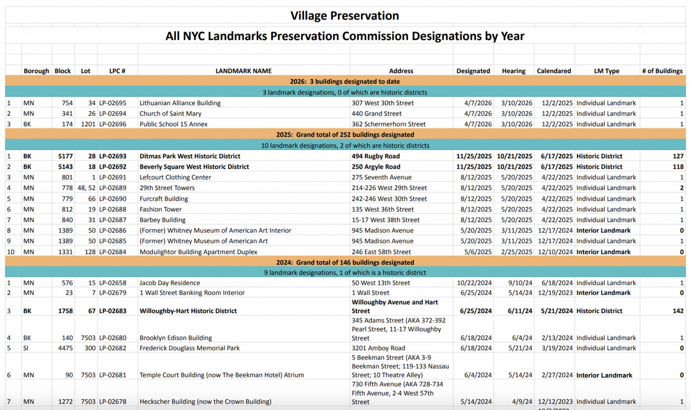
This comprehensive spreadsheet displays information in a digestible format that we couldn’t find anywhere else, so we created it ourselves! We initially compiled it for our report, “Analyzing New York City Landmark Designations: 1965-2025,” but quickly realized that the spreadsheet is also a valuable resource in its own right. We continue to update it periodically, so that all new and future designations will be included going forward. It’s particularly useful for showing (as no place else does) landmark designations in NYC in the order they occurred and separated by year. This allows trends and patterns over time to emerge (one we’ve noticed is that starting in the late de Blasio administration and accelerating through the entire Adams administration, the rate of new landmark designations in New York City have slowed to an unprecedented, all-time low).

The information is sourced from NYC Open Data, which does have a dataset of all landmarked sites (along with tons of other data about all sorts of NYC infrastructure and other things, well worth a look if you’re interested in the nitty gritty of how NYC functions), but an issue we encountered with NYC Open Data is that it can be rather unwieldy — it’s an unfiltered view into a vast amount of information, and we wanted to come up with a much more user-friendly way to share a subset of that content.
Admittedly, our spreadsheet is still, well, a spreadsheet. If you’re looking for a specific landmark or want to analyze data found in one of the columns, it serves those purposes well, but it has the inherent limitation of conveying geographic data in a non-spatial format. So, to dovetail with our all landmarks spreadsheet, we also created a timeline map that shows every individual landmark, interior landmark, and historic district within our neighborhoods of Greenwich Village, the East Village, and NoHo over time, from the Landmarks Preservation Commission’s inception to today. Viewed in tandem, these two resources tell you just about everything you might want to know about a given landmark or historic district.
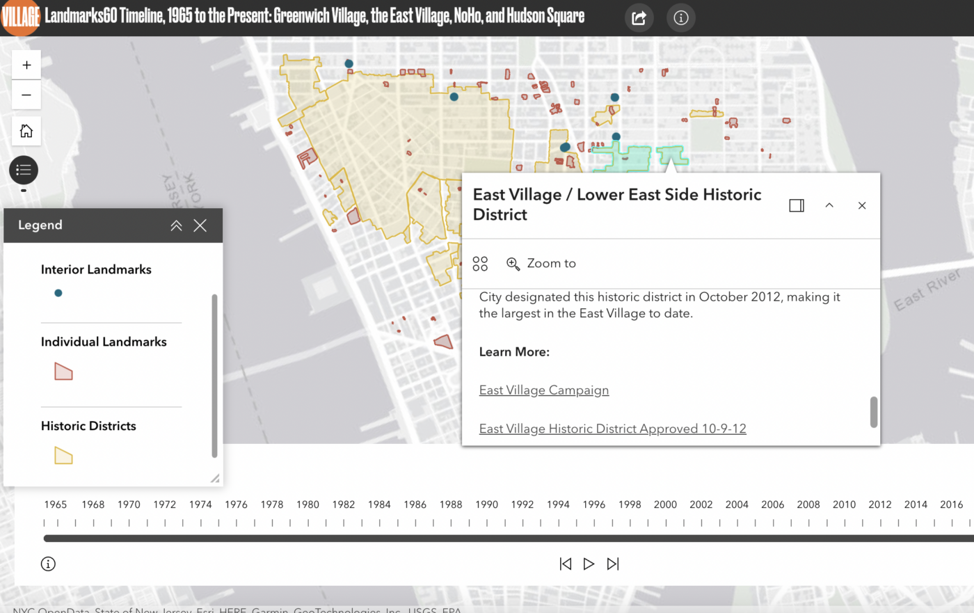
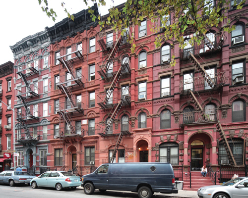
The timeline map indicates the designation date and construction date for each landmark, as well as offering photos, links to designation reports, and supplemental links to things like Village Preservation’s campaign pages and other relevant resources. You can then look up any landmark in the spreadsheet for even more details. For example, if you’re viewing the East Village/Lower East Side Historic District on the map, it’ll tell you that the district was designated on October 9th, 2012, further clarifying that “with Village Preservation’s support, the City designated this historic district in October 2012, making it the largest in the East Village to date.” There’s also the aforementioned photo, designation report link, and link to our East Village campaign page, where we continue to post updates about our ongoing advocacy efforts in the neighborhood.
If you then go to the spreadsheet, you can additionally learn that the East Village/Lower East Side Historic District contains 327 buildings and that the LPC hearing for consideration of its designation took place in June of 2012. Beyond that, you can extrapolate all sorts of interesting facts, including that the East Village/Lower East Side Historic District was one of five historic districts designated citywide that year, and that it was the second largest, surpassed only by the Park Slope Historic District Extension, which was nearly double its size with 613 buildings.
As a preservationist and researcher, I also found it interesting to note that there was a year and half between the hearing for the Park Slope Historic District and its ultimate designation, whereas the East Village/Lower East Side Historic District was heard and designated in less than four months total. Is this due to the relative sizes of the districts (the assumption being that it takes more time to finalize the research for twice the number of buildings)? Could it be thanks to our and others’ tireless efforts to get the East Village district designated? Were owners and neighbors in one neighborhood versus the other more or less supportive of designation? These are just some of the hypotheses and questions we can consider once we have this information in hand.

Whether you’re a researcher, someone who has a vested interest in a particular landmarked site, or are simply curious about the city around us and its historic assets, these are great tools to start to explore the landmarks of Greenwich Village, the East Village, NoHo, and beyond!

While we are so proud of all the landmarks we’ve been able to get designated over the years, our work is ongoing. You can also visit our Advocacy Campaigns page to learn about the places we’re still pushing to achieve landmark designation for, including Our Lady of Guadalupe and Most Holy Redeemer churches and a historic district in the area South of Union Square.